Washington Dulles International Airport (IAD)
Driving Directions / Travel by Car
(Washington, District of Columbia - DC, USA)
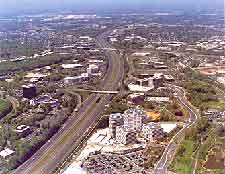
On the western outskirts of Washington DC, Dulles International Airport (IAD) is situated in the Herndon area. Sited on the northern side of the airport, the Dulles Toll Road runs in a northwest-southeast direction and connects the US-15 highway and the I-66 interstate.
Also close to Washington Dulles Airport, Arcola lies to the west, Ashburn, Leesburg and Sterling to the north, Reston to the east, and Chantilly to the south. Main roads nearby include the Loudon County Parkway and Old Ox Road on the western side of the complex, the John Mosby Highway (US-50) on the southern perimeter, and the Sully Road (US-28) on the eastern edge, leading to the Access Road.
Directions to Washington Dulles International Airport (IAD) from the city center:
- Dulles Airport is situated in northern Virginia
- The airport stands approximately 26 miles / 42 km to the west of Washington D.C.
- Take to main toll highway Dulles Toll Road (DTR US-267)
- The airport is also connected by other routes, including the I-66 interstate (Custis Memorial Parkway)
- Follow the signs
Directions to Washington Dulles International Airport (IAD) from downtown - via I-66
- Take the I-66 interstate (Custis Memorial Parkway) and head west
- Exit the highway at junction 67
- Follow the sign posts towards Dulles Airport, which is located roughly 16 miles / 26 km from the exit
Directions to Washington Dulles International Airport (IAD) from downtown - via the Dulles Toll Road (DTR US-267)
- The toll highway Dulles Toll Road is 14 miles / 22 km long
- The highway travels from the west of Capital Beltway to the airport
- Follow the signs
Washington Dulles International Airport (IAD): Virtual Google Maps
